 Parler
 Gab
Gab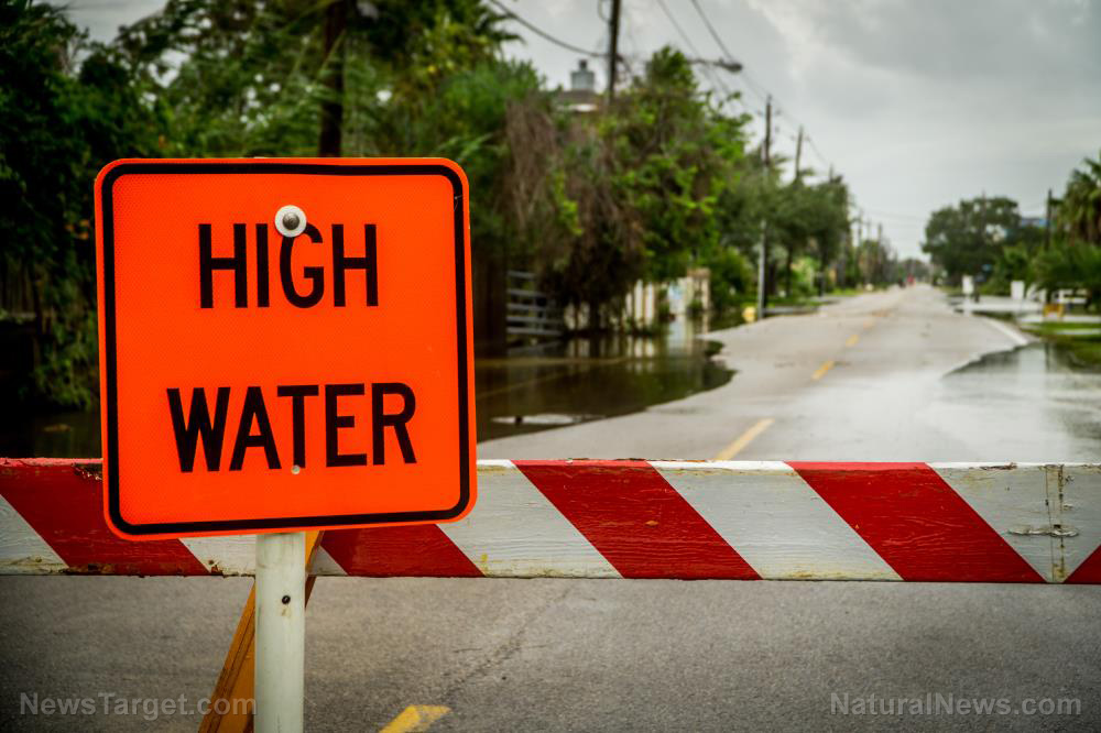
- FEMA removed 30+ Camp Mystic buildings from flood maps after appeals, enabling expansion into high-risk areas.
- Over 27 children, counselors and staff died in record floods that exceeded FEMA’s 100-year predictions.
- Experts say FEMA’s outdated models ignore smaller waterways and favor wealthier communities.
- Camp Mystic expanded despite repeated flood hazards and lax oversight.
- Survivors and officials question regulatory failures in disaster-prone regions.
FEMA decisions under scrutiny
FEMA initially categorized Camp Mystic’s original site as a “Special Flood Hazard Area” in 2011, requiring operators to carry flood insurance and adhere to strict construction rules. Yet the agency later reversed course. Records show that after appeals, FEMA removed 15 buildings in 2013 — part of the original campus — and an additional 15 from a new expansion site, Camp Mystic Cypress Lake, in 2019 and 2020. Syracuse University professor Sarah Pralle, a FEMA mapping expert, criticized the exemptions as “particularly disturbing,” especially given the camp’s responsibility for minors. “FEMA’s process seems to favor property owners who can afford the arduous appeals—even when vital safety regulations are at stake,” Pralle said. FEMA defended its approach, stating flood maps are “snapshots in time” meant to guide insurance, not predict floods. However, critics argue the agency’s reliance on outdated models—which ignore small creek risks and assume linear flood flows—left communities vulnerable. First Street, a climate data firm, found nearly all of Camp Mystic’s original site and much of the new location remain in high-risk zones under its independent analysis.History of neglect
The July 4 flood overwhelmed Camp Mystic with “unimaginable” force, according to survivors, but it was far from the first disaster. The camp had endured floods for its nearly century-long history, yet lacked early warning systems or mandatory evacuation plans. The Guadalupe River’s record-breaking surge, fueled by a hurricane’s 80 mph winds, outran even FEMA’s 1% annual flood thresholds — and struck at night, when many slept. Historically, Texas has grappled with flood mismanagement. A 2017 study by Antonia Sebastian and Russell Blessing warned that FEMA’s one-dimensional modeling overlooks areas like the Guadalupe Basin, where waters spread indiscriminately. Their call for modern tools, like 3D hydrology systems, went unheeded. Camp Mystic’s 2020 expansion further lowered safeguards. State records confirm a licensing inspection on July 2 — two days before the flood — gave the camp a green light despite its proximity to the river.The politics of floodplain appeals
Property owners commonly challenge FEMA-designated hazard areas to bypass insurance costs and construction limits. Federal data analyzed by Pralle shows 90% of such appeals succeed, disproportionately favoring wealthier, whiter communities. Chris Steubing of the Texas Floodplain Management Association acknowledged FEMA’s process is “arduous” but noted it allows local flexibility. Yet he admitted the July storm was so extreme that “even elevated structures might not have lasted.” Still, critics argue lax oversight enabled Camp Mystic to grow, exploiting a system tilted toward developers.A watershed moment for flood preparedness?
The Camp Mystic tragedy has national implications. With increasing extreme weather occurrences, FEMA’s mapping flaws now endanger more lives. As survivors mourn, policymakers face pressure to update risk assessments and ensure regulations protect vulnerable populations — not just wealthy landowners. “This isn’t just about Camp Mystic,” said survivor and counselor Emily Nguyen. “It’s about every community on the edge of a floodplain. The maps matter, and so do the choices officials make when lives are in the balance.” For now, families await answers — and hope the camp’s lost children become catalysts for change. Sources for this article include: NYPost.com APNews.com ClaimsJournal.comUN accuses Israel of starving Gaza civilians as hunger deaths mount
By Belle Carter // Share

Israeli tanks enter Deir al-Balah: A new phase in the Gaza conflict
By Zoey Sky // Share

Mexico mandates biometric digital ID system in major overhaul of national identification
By Laura Harris // Share
Trump warns BRICS over dollar challenge, threatens 10% TARIFF on member nations
By Laura Harris // Share

Study: Childhood OBESITY crisis reaches alarming heights
By Ava Grace // Share
Seven illegals, including five Iranians, arrested at the northern border
By Ramon Tomey // Share

No Deal on Iran: Why the West's Unreasonable Demands Will Lead to Global Catastrophe
By healthranger // Share


These 4 antioxidants could be the missing link for tired, dull skin
By isabelle // Share

Humanoid robots enter American homes as Gatsby launches autonomous cleaning service
By isabelle // Share


Modest curcumin dose shows blood sugar improvement in older prediabetic adults
By isabelle // Share